Translate this page:
| Pincode | 431720 |
| Name | Shikh Rajura B.O |
| District | Parbhani |
| State | Maharashtra |
| Status | Branch Office(Delivery) |
| Head Office | Parbhani H.O |
| Sub Office | Palam S.O |
| Location | Palam Taluk of Parbhani District |
| Telephone No | Not Available |
| SPCC | Parbhani-431401 |
| Department Info | Pharbhani Division Aurangabad Region Maharashtra Circle |
| Address | Maharashtra 431720, India |
| Services | |
| Indian Postal Code System Consists of Six digits. The first to digits represent the state, the second two digits represent the district and the Third two digits represents the Post Office.In this case the first two digits 43 represents the state Maharashtra, the second two digits 17 represent the district Parbhani, and finally 20 represents the Post Office Shikh Rajura B.O. Thus the Zip Code of Shikh Rajura B.O, Parbhani, maharashtra is 431720 | |
| Pincode | 431720 |
| Name | Kerwadi B.O |
| District | Parbhani |
| State | Maharashtra |
| Status | Branch Office(Delivery) |
| Head Office | Parbhani H.O |
| Sub Office | Palam S.O |
| Location | Palam Taluk of Parbhani District |
| Telephone No | Not Available |
| SPCC | Parbhani-431401 |
| Department Info | Pharbhani Division Aurangabad Region Maharashtra Circle |
| Address | Maharashtra 431720, India |
| Services | |
| Indian Postal Code System Consists of Six digits. The first to digits represent the state, the second two digits represent the district and the Third two digits represents the Post Office.In this case the first two digits 43 represents the state Maharashtra, the second two digits 17 represent the district Parbhani, and finally 20 represents the Post Office Kerwadi B.O. Thus the Zip Code of Kerwadi B.O, Parbhani, maharashtra is 431720 | |
| Pincode | 431720 |
| Name | Palam S.O |
| District | Parbhani |
| State | Maharashtra |
| Status | Sub Office(Delivery) |
| Head Office | Parbhani H.O |
| Sub Office | |
| Location | Palam Taluk of Parbhani District |
| Telephone No | |
| SPCC | Parbhani-431401 |
| Department Info | Pharbhani Division Aurangabad Region Maharashtra Circle |
| Address | Palam, Maharashtra 431720, India |
| Services | Business Parcel Business Post Direct Post EMS (International Speed Post) E-Payment Epost Franking Machine IFS Inland Speed Post Instant Money Order International Mails Money Order National Bill Mail Service National Pension Scheme Philately Postal Banking Service Postal Life Insurance Postal Orders Postal Stationary Postbag and Postbox Registered Posts |
| Indian Postal Code System Consists of Six digits. The first to digits represent the state, the second two digits represent the district and the Third two digits represents the Post Office.In this case the first two digits 43 represents the state Maharashtra, the second two digits 17 represent the district Parbhani, and finally 20 represents the Post Office Palam S.O. Thus the Zip Code of Palam S.O, Parbhani, maharashtra is 431720 | |
| Pincode | 431720 |
| Name | Pethpimpalgaon B.O |
| District | Parbhani |
| State | Maharashtra |
| Status | Branch Office(Delivery) |
| Head Office | Parbhani H.O |
| Sub Office | Palam S.O |
| Location | Palam Taluk of Parbhani District |
| Telephone No | Not Available |
| SPCC | Parbhani-431401 |
| Department Info | Pharbhani Division Aurangabad Region Maharashtra Circle |
| Address | Maharashtra 431720, India |
| Services | |
| Indian Postal Code System Consists of Six digits. The first to digits represent the state, the second two digits represent the district and the Third two digits represents the Post Office.In this case the first two digits 43 represents the state Maharashtra, the second two digits 17 represent the district Parbhani, and finally 20 represents the Post Office Pethpimpalgaon B.O. Thus the Zip Code of Pethpimpalgaon B.O, Parbhani, maharashtra is 431720 | |
| Pincode | 431720 |
| Name | Pethshivani B.O |
| District | Parbhani |
| State | Maharashtra |
| Status | Branch Office(Delivery) |
| Head Office | Parbhani H.O |
| Sub Office | Palam S.O |
| Location | Palam Taluk of Parbhani District |
| Telephone No | Not Available |
| SPCC | Parbhani-431401 |
| Department Info | Pharbhani Division Aurangabad Region Maharashtra Circle |
| Address | Maharashtra 431720, India |
| Services | |
| Indian Postal Code System Consists of Six digits. The first to digits represent the state, the second two digits represent the district and the Third two digits represents the Post Office.In this case the first two digits 43 represents the state Maharashtra, the second two digits 17 represent the district Parbhani, and finally 20 represents the Post Office Pethshivani B.O. Thus the Zip Code of Pethshivani B.O, Parbhani, maharashtra is 431720 | |
| Pincode | 431720 |
| Name | Pharkanda B.O |
| District | Parbhani |
| State | Maharashtra |
| Status | Branch Office(Delivery) |
| Head Office | Parbhani H.O |
| Sub Office | Palam S.O |
| Location | Palam Taluk of Parbhani District |
| Telephone No | Not Available |
| SPCC | Parbhani-431401 |
| Department Info | Pharbhani Division Aurangabad Region Maharashtra Circle |
| Address | Maharashtra 431720, India |
| Services | |
| Indian Postal Code System Consists of Six digits. The first to digits represent the state, the second two digits represent the district and the Third two digits represents the Post Office.In this case the first two digits 43 represents the state Maharashtra, the second two digits 17 represent the district Parbhani, and finally 20 represents the Post Office Pharkanda B.O. Thus the Zip Code of Pharkanda B.O, Parbhani, maharashtra is 431720 | |
| Pincode | 431720 |
| Name | Sailu B.O |
| District | Parbhani |
| State | Maharashtra |
| Status | Branch Office(Delivery) |
| Head Office | Parbhani H.O |
| Sub Office | Palam S.O |
| Location | Palam Taluk of Parbhani District |
| Telephone No | Not Available |
| SPCC | Parbhani-431401 |
| Department Info | Pharbhani Division Aurangabad Region Maharashtra Circle |
| Address | Palam, Maharashtra 431720, India |
| Services | |
| Indian Postal Code System Consists of Six digits. The first to digits represent the state, the second two digits represent the district and the Third two digits represents the Post Office.In this case the first two digits 43 represents the state Maharashtra, the second two digits 17 represent the district Parbhani, and finally 20 represents the Post Office Sailu B.O. Thus the Zip Code of Sailu B.O, Parbhani, maharashtra is 431720 | |


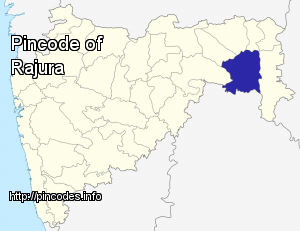
Rajura is a city and a municipal council in the Chandrapur district of the Indian state of Maharashtra.
Rajura is located at 19.78°N 79.37°E / 19.78; 79.37 in Maharashtra, the second most populous and the third largest in area of India's 28 states. The city has an average elevation of 181 metres (593 feet). Rajura lies on the banks of the Wardha River and falls within the coal belt of Central India.
According to the 2001 Indian census, Rajura has a population of approximately 25,843 (52% male, 48% female). Children under age 6 constitute approximately 15% of the population. Rajura's average literacy rate of 72% (77% among males, 67% among females) significantly exceeds the national average of 59.5%.
Nearby Towns More Info